
 Your Account
 Email Sign-Up
 Buy Annual Pass
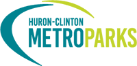


ORGANIZATION OVERVIEW & HISTORY
The Huron-Clinton Metropolitan Authority, Metroparks, is a regional special park district encompassing Livingston, Macomb, Oakland, Washtenaw, and Wayne counties.
It was sanctioned by the Michigan State Legislature in Act No.147 of the Public Acts of 1939 and was approved, in 1940, by the residents of the five counties. The Board of Commissioners held its first meeting in 1941 and funding for the Metroparks became available in 1942.
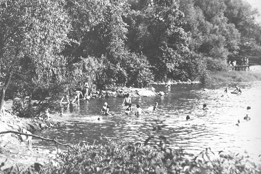
The governing body of the HCMA is a seven-member Board of Commissioners. Two of the members are selected by the governor, to represent the district at large, and the other five are selected by the Board of Commissioners from each of the five member counties.
The Metroparks’ 2017 budgeted expenditures are $62 million. They are staffed by 203 full-time and over 800 part-time personnel. The Metroparks are funded, principally, by a property tax levy, limited to one-quarter of one mill (the rate for 2017 is .2146 mills), and by revenues from vehicle entry fees and other user fees for various facilities such as golf courses. A Metroparks vehicle pass is required to enter any Metropark.
Currently, 13 Metroparks cover almost 25,000 acres and serve over 7.3 million visitors on average annually. The Metroparks are located along the Huron and Clinton rivers, providing a greenbelt around the Detroit metropolitan area. The parks are, generally, more than 1,000 acres each, with Stony Creek and Kensington being more than 4,400 acres each.
The Metroparks provide a natural oasis from urban and suburban life. They provide an ever-growing variety of year-round, outdoor recreational and educational activities in safe, clean environments. Picnicking, fishing, swimming, boating, hiking, nature study, biking, golf, disc golf, winter sports and a host of special outdoor programs and events are available within a short drive to southeast Michigan residents.
The Metroparks are recognized for their extensive paved hike/bike trails and for their golf courses. More than 55 miles of paved hike/bike trails course through the Metroparks and some of these trails connect with many more miles of trails outside the Metroparks. The system operates 7 regulation golf course and one par-3 course.
The HCMA has made a strong commitment to environmental education and preservation. It operates 10 full-service interpretive centers — nature, farm and historical — that provide a variety of programs, both on site and off site, for almost 1.5 million people annually. In addition, it boasts three mobile learning centers to engage with schools, community centers, fairs and other locations in Southeast Michigan to conduct nature, farm and history programs for groups that may not have the means or opportunities to visit a Metropark.
Mission Statement
The Huron-Clinton Metropolitan Authority, a regional park system created in 1940 by the citizens of Southeast Michigan, provides excellent recreational and educational opportunities while serving as stewards of its natural resources. Our efforts are guided by the belief that the use of parks and exposure to natural environments enhance society’s health and quality of life.
Vision
The Metroparks offer 365-day access to open space, outdoor experiences, and abundant resources for the communities of Southeast Michigan now and into the future.
Core Values
The Metroparks provide unique quality-of-life amenities to Southeast Michigan through our commitment to:
- Excellence in public service, stewardship, and programming; Sustainability in balancing the environmental, social, and economic impacts of the Metroparks; Responsibility in planning, development, and maintenance; and Connectivity to the places and people we serve.
ORGANIZATION HISTORY
Introduction
In the late 1930s, the people of southeast Michigan were facing a crisis in outdoor recreation—namely the lack of public parks. Parkland, about 6,000 total acres, was so limited for the three million residents of five southeastern counties that long lines of vehicles often formed waiting to find parking places, and picnickers waited hours for places to eat at existing parks. Throughout the region’s 3,310 square miles, there were only four public bathing beaches and, although the region had about 600 lakes, the public had access to only 14 of them. The general public was virtually barred from the lakes and streams that gave the area much of its charm and attraction, and the residents were deprived of the many benefits that arise from participating in outdoor recreation. This was the setting in which the Huron-Clinton Metropolitan Authority was born.
The idea for a regional park system in southeast Michigan can be traced back to the minds and work of two men, Dr. Henry S. Curtis and Professor Harlow O. Whittemore. Dr. Curtis was a nationally recognized expert in recreation, having been director of playgrounds for New York City, the District of Columbia and the State of Missouri. He had written several books on recreation and also had been an organizer and secretary for the National Recreation Association.
Professor Whittemore was professor and chairman of Landscape Design at the University of Michigan. He, too, was interested in parks and recreation and had helped design and develop many public parks and private estates.
In 1936, Dr. Curtis directed a recreational survey of Washtenaw County in southeast Michigan for the National Youth Administration. The survey revealed that there were no public recreational facilities in the county except for one small county park and that all the lakes suitable for recreation were surrounded by private developments. The survey brought Dr. Curtis into contact with Prof. Whittemore, who had long been interested in the recreational possibilities of the Huron River Valley. The Huron River is one of three rivers that course through the five-county region. As the men discussed and explored options for developing recreational opportunities for Washtenaw County, they decided that the most practical solution would be to develop in the Huron River Valley. Their thinking soon turned more grandiose as they began to see the benefits of developing both the Huron River Valley and the Clinton River Valley. Together, the two rivers formed a 120-mile horseshoe around the Detroit metropolitan area with a radius that varied from 25 to 60 miles to the center of the City of Detroit, which had the largest population of the region.
From the beginning, they envisioned a limited-access parkway connecting a series of four to five large (more than 1,000 acres) parks and that ran along the two rivers from the mouth of the Clinton River on Lake St. Clair to the headwaters of the two rivers to the west and then to the mouth of the Huron River on Lake Erie.
A Park System is Born
The plan quickly gained support from other members of the University of Michigan faculty, citizen groups and other public agencies In Washtenaw County. In 1937, a group of private individuals, including university professors and businessmen, formed a committee to advance their plan to people throughout the five-county region. At first called the Huron Valley Committee, it later became known as the Detroit-Huron-Clinton Park and Parkway Association to reflect the expanding scope and support of the plan. Over the course of the next several years from 1937 to 1939, the concept of developing large recreation sites along the two rivers connected by a limited access highway gained support from academics, influential business leaders, local and state public officials and, most importantly, the general public. In 1939, legislation was introduced into the State Legislature that authorized the establishment of a regional park system—Huron-Clinton Metropolitan Authority. The enabling legislation was approved and signed into law as Public Act 147 of the Public Acts of 1939, with the provision that it be approved by the electorate of the five counties in the general election of 1940.
A massive marketing campaign by the Detroit-Huron-Clinton Park and Parkway Association took place during the next year primarily focusing on the need to provide a regional answer for a regional problem. The region was woefully lacking in outdoor recreation space. The Detroit metropolitan area had about one acre of public parkland per 500 people, while the minimum national standard set by the National Park Service was one acre per 100 people. Separately each local government, city or county could do little in the way of planning, developing and maintaining adequate large recreational facilities because the costs would be prohibitive. Also, the land for parks was not available in the more populous parts of the region yet those populated areas had no power to purchase and create parks outside their boundaries. The beautiful valleys of the Huron and Clinton rivers were ideally suited to recreation sites connected by a landscaped parkway and they were close to the heart of Detroit. Revenues for this new system would come from a quarter mill ad valorem tax on the property within the five counties, as well as through grants from other governmental agencies.
The enabling legislation was approved by a two-to-one margin during the 1940 election. Almost immediately after the 1940 election, however, the issue was raised of taxing residents of a given jurisdiction for parks acquired outside the jurisdiction. Although the residents of Detroit and Wayne County had approved the enabling legislation, the Wayne County Board of Supervisors brought suit against the Authority questioning its legal power to levy a quarter mill property tax. The Board argued that Wayne County, which included the City of Detroit, would pay the lion s share of the taxes, but would not receive the benefits of a large park nearby. The legal issue was resolved in the courts in favor of the HCMA, so in early 1942 the way was cleared for the HCMA to begin collecting funds and to begin acquiring and developing parks. However, the issue of park distribution vis-a-vis the City of Detroit has continued to come to the forefront to this day. More on this point later.
Placing the First Huron-Clinton Metroparks
Having the general location of parks in mind, i.e., along the Huron and Clinton River valleys, the HCMA staff and Board of Commissioners set out to determine where along those routes would be best to place parks. The young park system made use of several studies and information that had been gathered earlier by the Detroit-Huron-Clinton Park and Parkway Association. In the late 1930s, this group had worked to get recreational planning studies completed by the National Park Service and Michigan Department of Conservation. Both provided detailed information on the region’s demographics, physical features and topography, forest cover and agricultural land, industrial and business concentration, road systems and traffic flows, political subdivisions, and current recreational areas and facilities.
The National Park Service Survey on “Recreational Use Of Land” (1938) also identified several recreation planning principles for metropolitan areas.
- The existing transportation methods, primarily private automobile, made possible the frequent use of recreation areas within a 50-mile radius of the central city, and this zone could be reasonably accepted as the metropolitan regional planning unit.
- In the general planning of recreational areas, primary importance should be given to preserving natural topographic features such as streams and stream valleys, lakes and lake shores, wetlands areas, forested areas and areas of special historic significance to the region.
- The responsibility for providing recreational areas in metropolitan regions should be assumed by several different public agencies—the state, the metropolitan park district, the county and the city. The metropolitan park district’s function is to assume major responsibility for the planning, development and operation of recreation areas in the zone extending from near the boundaries of the central city to the limits of the territory that has already become suburban-urban or is tending that way.
- The central cities will probably continue to acquire and administer recreational areas within their own borders.
These principles strongly influenced the placement decisions made by the HCMA. Using this information, along with the general guidelines for parks development as outlined by the enabling legislation, the HCMA saw its role in providing parks as complementing or supplementing what other public agencies in the region were doing, not replacing the activities and park developments of other agencies. HCMA leaders envisioned large parks of 1,000 or more acres that would be in the zone outside the central city and primarily along the two rivers. Developing a few larger areas rather than many smaller ones would provide economy in operations and would have a variety of facilities and activities so that people would be willing to drive distances, up to 50 miles, to use them. Other characteristics considered in determining whether a site would be suitable for parkland included: a variety of topographical features; next to or including water; marginal economic value for agricultural or industrial purposes; within 50 miles of the region s population concentration (Detroit and adjacent cities); close to existing or planned highways; and a sufficiently large contiguous tract.
In the early 1940s, the State of Michigan through its Department of Conservation was also beginning a major effort to increase its park and recreation lands in Southeast Michigan from its 194 1 total of 14 state parks or recreation areas containing about 955 acres. It identified about 100,000 acres in southeast Michigan as having potential as public parklands. So, early in the park siting process, the HCMA worked with the Michigan Department of Conservation, attempting to locate and develop parks that would complement rather than compete with the other’s parks. In the same report referred to earlier, the National Park Service recommended that the state take the responsibility of providing natural recreational areas in the outer reaches of the metropolitan region (20-50 miles from the central city), i.e., areas that would preserve large tracts for more passive outdoor activities such as hunting, fishing, camping, hiking and picnicking. While the HCMA’s enabling legislation also mentioned these as possible activities in the regional parks, the HCMA Board decided that parks under its control would be more intensively developed to provide swimming beaches, playgrounds, ball diamonds, large picnic areas and winter activities such as sledding and skating. HCMA decided early that its parks would not provide open hunting and family camping (group camping areas were to be developed) and that its individual parks would not typically be as large as the state areas.
Armed with comprehensive and recent information, the guiding principles for recreational planning in a metropolitan area as laid out in the National Park Service report, and its plan to work cooperatively with the state, the HCMA placed its first several parks. Note that there had been no specific survey conducted of the general population about what specific facilities and activities should be provided in the parks. Public recreational land was in such limited supply that a park providing any outdoor activity would be heavily used. But areas for water activities such as swimming, boating and fishing, along with areas for picnicking and hiking, appeared to be the most urgency needed and would be most heavily used.
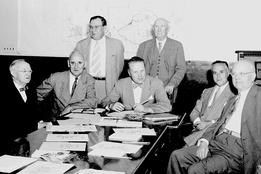
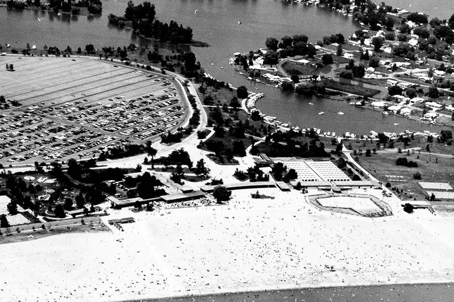
The first two sites located and developed were St. Clair Beach (now called Lake St. Clair Metropark), along Lake St. Clair just south of the mouth of the Clinton River and about 22 miles north of central Detroit, and Kensington Metropark located along the Huron River at the border of Oakland and Livingston counties about 35 miles from central Detroit. The sites were within 50 miles of the region’s population center, they were located along major roads, water was the central feature of the sites, the tracts were large and the land was of marginal economic value. In fact, much of the land in both of the parks could be characterized as “swamp. The first development to take place in the 550-acre Metro Beach (now 770 acres) was to dredge two million cubic yards of sand from the lake to raise the land level about three to four feet. The first improvement at 3,600-acre Kensington (now 4,357 acres) in 1946 was to construct a dam south of the park along the Huron River, thereby enlarging the existing 70-acre lake to one of about 1,200 acres. Surrounding the lake were morainal hills, some of which had been cleared for agriculture, but many of which were still wooded. The varied topographical features made for a spectacular natural park setting. Two new swimming beaches, fishing and boating opportunities on the lake, along with picnicking, play fields, hiking trails and camping for organized groups on land, made this park an instant success when it opened in 1948. By the second summer of operation, a warm, sunny, weekend day could draw up to 50,000 visitors at Kensington. By the mid-1950s the park had an annual visitation of more than one million people. Today, this park continues to be the most heavily used of all the HCMA Metroparks, hosting about 2.6 million visits per year. Located along a main highway artery for the region when it opened, accessibility to the park improved even more in the 1960s with the construction of 1-96, an east-west expressway coming out of Detroit that touched the southern boundary of the park. Another expressway, US-23, was constructed that ran north-south and intersected 1-96 about three miles west of the park. This gave people from the southern part of the region easy access to the park.
When Metro Beach opened in 1950, it was an immediate success as well. With a manmade lakefront beach almost a mile long, it too hosted crowds of from 35,000 to 50,000 people per day during the warm summer months. Today, it is the second most heavily used Metropark with visitation of 1.25 million to 1.5 million people annually. A major expressway that runs north-south through Detroit and passing about five miles to the west of the park, makes this park easily accessible by automobile to a large part of the region’s population.
Within the HCMA’s first 10 years, a couple other regional parks were planned and development started. Lower Huron opened in 1951 to become the first Metropark located in Wayne County. Both it and Hudson Mills, which was located in Washtenaw County, were more linear parks that had the Huron River running through them. They opened as primarily picnicking parks. Their placement continued the goal of developing a ring of parks around the metropolitan area.
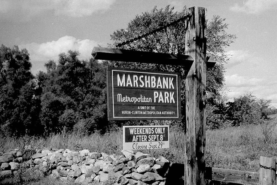
At about the same time these four parks were being developed, the HCMA began to operate three other parks that certainly didn’t fit into the original planning and development scheme as envisioned by the founding fathers and later the HCMA Board. All three became a part of the park system because they were donated. Although all three were very small, ranging in size from 50 acres to 125 acres, and although one wasn’t located along either the Huron or Clinton rivers, the HCMA Board decided that politically it would be best to accept and operate these parks as part of the system. A 115-acre parcel, Marshbank Metropark, was donated by industrialist Howard Bloomer. Its small size and distance from any larger Metropark made operating it difficult. In 1985, it was deeded to a local governmental agency with the stipulation that it continue to be maintained as a public recreational facility. The other two parks, Delhi and Dexter-Huron, were located along the Huron River in Washtenaw County and were near Hudson Mills, the staff of which can economically maintain the two parks. With picnicking and canoeing along the river as the main activities, these two parks were more local in nature, however.
Long-Term Placement and Acquisition Plans
By the early 1960s, the Authority had about 16,000 acres in seven parks either in operation or under development. As it continued to grow and make decisions on where best to place regional day-use parks, the HCMA began working to develop a long-term, comprehensive recreational plan that would facilitate decisions on future land purchases. In 1962, the HCMA teamed with the Detroit Metropolitan Area Regional Planning Commission to develop a regional recreational lands plan for southeast Michigan to 1980. The plan was based on several intensive studies that had been completed by the planning commission in the late 1950s. First, an inventory and analysis of existing public recreational land in the region had been done. Second, a park user’s survey of eight selected regional parks had been completed. A ” home survey, done by mail to gain basic demographic information and to obtain information about non-users of regional parks, had also been completed. Finally, a survey of potential recreational sites was conducted, selecting lands on the basis of natural features that would make them appealing as parks—varying topography, bodies of water, stream and river valleys, and wooded. Using this information, the regional recreation lands plan was developed indicating how much land for regional parks would be needed over the next 20 years, the type of facilities that would be needed and the general location for each park. The plan also estimated the financial ability of the HCMA to provide additional regional day-use parks and it suggested priorities for land acquisition.
To identify the supply of land and natural resources available for parks, the plan divided the five-county area into four natural resource regions: morainal hills, which contained the most rugged topography; upland lake region, which surrounded the morainal hills and had gently rolling terrain with many lakes and meandering streams; lake plain region, which was located between the upland lake area and the Great Lakes waterfront, was flat with only shallow river valleys to provide topographic relief (the City of Detroit and its suburbs are located in this area); and the waterfront, which included land along Lake St. Clair, the Detroit River and Lake Erie.
Land needs for regional parks to 1980 were estimated. Using guide-lines developed in the studies of the 1950s, it was estimated that about 90,000 acres would be needed to supply the day-use demand of the six million people expected to live in the region by 1980. Some of the guidelines used to arrive at this figure were:
- An estimated 15 percent of the population would be expected to use regional parks on an average summer Sunday;
- The amount of land needed per person varied with activity, but in general, one acre was needed for every 10 people visiting a regional park per day;
- Forty miles or one hour driving time was the maximum distance or time a majority of the people would travel to use a regional park facility;
- Picnicking, rest-relaxation (sightseeing) and swimming would be the primary activities.
To better determine how these 90,000 acres should be distributed within the region, the five counties were divided into three sub-regional areas. The regions were identified based on a comparison of what recreational opportunities were currently available and what the park user survey stated people preferred, and on the proposed regional highway plan. The user survey indicated that ease of movement and quality of the park were the major factors attracting people. The region was divided into three sectors—northeast sector, northwest sector and southwest sector — and the recreational needs of these particular areas were identified. For example, the northeast sector was found to have sufficient swimming and beach facilities, but insufficient picnicking areas, while the situation was just the reverse in the southwest sector, which included Wayne County. Because the southwest sector was already heavily developed, resources for recreation were very limited. Additionally the area was primary glacial lake plain so it wasn’t conducive to providing water-oriented facilities. As a result, swimming and boating facilities were almost non-existent in this sector. The plan did not separate Detroit as a fourth sector. It assumed that Detroit residents were equally close to any of the three sectors and so would use all three.
Examining the growth trends for the metropolitan region and the management policy of the HCMA, the plan estimated the financial ability of the Authority to provide additional recreational facilities. It estimated that of the HCMA should be able to provide 30,000 of the 90,000 acres of regional parkland projected to be needed by 1980.

New Placement Guidelines
With 30,000 total park acres as a goal, the plan also identified guidelines for determining where, in general, the parks should be placed:
- Distribution of additional park acreage and the facilities provided thereon should be related to the needs and population distribution of the sub-regional sectors identified by the plan;
- Sites should be located within an hour driving time from the center o.” population of each sector, and close to present or proposed major highways;
- Advantage should be taken of natural scenic attractions, and the potential for dam impoundment;
- Sites should be large enough to provide a full range of day-use activities.
The HCMA used these guidelines and the information of the plan, which included specific areas within the five-county region that should be considered for park development, to guide its land purchases for the next 1 5 to 20 years. Beginning in the 1960s and going on into the 1970s and 1980s, the HCMA purchased property for three Metroparks in Wayne County (southwest sector) located along the Huron River—Willow, Oakwoods and Lake Erie. Two focused on water activities with two pools, a marina and boat launch being developed in the parks, while the other focused on preserving a natural area and providing nature interpretation. Three thousand-acre Wolcott Mill Metropark, which is still under development today, was located in central Macomb County (northeast sector). It focused on passive facilities such as history and farm interpretive centers and picnicking. In central Oakland County (northwest sector) a 2,225-acre park was established at the headwaters of the Huron River. Natural area preservation, along with environmental education, was its primary focus. Another park, Huron Meadows, was developed in this sector along the Huron River between Kensington and Hudson Mills. It provided a golf course, natural area with trails and picnicking for people in the western reaches of the region.
The system did not reach the planned goal of owning 30,000 acres of parkland by 1980, but the region s population did not reach six million by 1980, either. The system currently includes a total of 24,000 acres in 13 Huron-Clinton Metroparks serving a regional population of about 4.6 million people. Considerable shifts in the population from urban areas to suburban areas has taken place since the placement of parks, which in general has brought the region’s population closer to the parks.
In general, the placement of parks followed the ideas set forth by the system’s founders, that is, they were located on or close to the Huron and Clinton rivers. In both major phases of parkland acquisition, extensive data were gathered before any purchases were made. In the second phase of development especially, an extensive planning process, regional in scope, was used to guide the placement of parks. Unlike the first phase, the second phase included surveys of users and non-users to identify their needs.
Controversy Regarding Placement
Some people in the region did not agree with the placement of Metroparks as outlined in the plan, however. The placement of the parks had all been predicated on the willingness and ability of people to travel by private automobile to get to the parks. In the first phase of park development it was determined that people would be willing to travel up to 50 miles to visit a large park located in attractive natural settings and having a variety of facilities. Survey data used in the planning of the second phase of park development suggested that parks be within an hour drive of population centers of the sub-sectors. In the late 1960s to early 1970s, leaders in Detroit and Wayne County questioned this basic premise. They argued that 28 percent of the people in Detroit did not have access to an automobile, and many that did were unwilling to travel up to an hour to use a regional park. Yet the people of this area were paying more to support the Metropark system than other parts of the park district.
With political pressure mounting for the HCMA to locate a park within the City of Detroit close to a large concentration of people, the Authority reconsidered its long-range park plan. Because there were no large parcels of land available within the city to develop a new park, commissioners and staff developed plans to renovate and to take over the operation of Belle Isle, a 1,000-acre island park that was Detroit s largest and most heavily used park facility. The plan was well received by city leaders, and in 1970, the voters of the City of Detroit approved the “idea” of leasing the park to HCMA. The plan had a redevelopment price tag of $39 million, well beyond the financial capacity of the HCMA at that time. To pay for Belle Isle s redevelopment and operation, along with continuing the HCMA s plan of purchasing property in other parts of the region, a proposition to increase the HCMA’s property tax levy by a quarter mill was put before the voters of the entire region in 1972. This proposition was defeated, however. In 1973, the HCMA went back to the City of Detroit with another plan to lease the park and to undertake a less ambitious redevelopment effort. This would be funded by an introduction of vehicle entry fees into the Metroparks and by pushing back the timetable for parkland purchases in other parts of the region.
By 1973, a new city administration was in place and it did not look favorably on this new plan. The new administration saw this as giving away control of one of the cities jewels to a regional organization, an outsider. Rather, the new city leaders favored the ideas of the HCMA granting money directly to Detroit for it to use in the operation of city parks, or in the building of smaller parks within the city. The HCMA rejected both of these suggestions. Smaller parks would not be regional in nature and so would be readily criticized by citizens of other counties, and if done, this could lead to smaller parks throughout the entire region, destroying the original purpose of the HCMA and increasing the costs of maintaining the parks considerably.
This issue became so politically sensitive that state legislative hearings were held in 1973 to consider changing the HCMA s enabling legislation. Changes considered and debated during the hearings Included changing the representation on the Board of Commissioners to include a member from the City of Detroit, requiring that the HCMA grant funds to Detroit for operation of city parks, and changing the HCMA’s plans for locating large parks so that they are more accessible to the residents of Detroit. HCMA commissioners and staff countered that HCMA had attempted to have a presence within the City by taking over the operation of Belle Isle, but had been rejected. It had looked for other sizable tracts of land within or near the city to develop, but none existed. Further, HCMA was already providing its piece of the region’s recreational puzzle by preserving large tracts of quality natural areas and operating regional outdoor recreational facilities, and that 50 percent of the Metroparks visitation was from Wayne County. Although no parks were located within Detroit city limits, two Metroparks were already in operation within the county and two more were planned. The founding fathers of the HCMA never intended it to be the only agency responsible for providing the region s recreational opportunities. The area s cities and counties, as well as the state, also played a role in providing various types of outdoor recreation.
No changes were made to the HCMA’s enabling legislation in the 1970s, but to this day, the issue of providing more recreational opportunities for the residents of the region’s central city has not been resolved. At various times through the ensuing years, the HCMA, Michigan Department of Natural Resources (formerly Department of Conservation) and Wayne County all have tried to develop a park and/or recreational presence within the Detroit City limits. Although the Belle Isle initiative failed, and no parks have been established to date, for years the HCMA has offered educational outreach programs to groups within the city through its interpretive program. Since the late 1960s, interpreters have conducted nature and cultural programs for groups throughout the region. In 1995, a 48-foot exhibit trailer, or “Mobile Learning Center,” was put on the road with the specific goal of reaching people within areas of the region who were less likely to be able to visit a park.
For the last couple years, the idea of partnering with other agencies on a recreational project in Detroit has made a resurgence. HCMA, Wayne County Parks and Recreation and the City of Detroit have been meeting to develop an agreement and plan for the renovation and operation of Fort Wayne, a site of about 70 acres within the city that has considerable historic significance to the area. The project is too big and too costly for one agency to take on by itself, but by working together, It is hoped that a viable program can be developed for this site.
It is still too early to know whether the three agencies will succeed in coming together on this effort, but it is clear that the general issue of developing and operating a recreational facility closer to the population concentration within the Authority’s district will be a major issue facing the HCMA in the near future vis-a-vis placement of parks.
Conclusion
The Huron-Clinton Metroparks system is now a mature regional park system in terms of placing new parks. While location is only one variable in determining the successful marketing of a park system, it is a critical factor. The Metroparks’ experience in placing day-use parks over a regional area can be used to illustrate several points for practitioners to consider. Some park professionals may take the “build it and they will come,” approach towards park placement decisions. To the extent that the site has exemplary natural features such as varied topography, water, etc., and/or considerable historical significance, this may be a workable approach. But, this approach can be hit or miss in terms of whether the target market will heavily use a site. In addition to considering the physical features of a site, location decisions also need to consider accessibility, or the time, distance and ease of traveling to a site, as well as the programs and facilities to be offered at the site. Balancing these considerations is difficult, but it is at the core of a successful park placement process.
Locating Metroparks in a ring around the Detroit metropolitan area where the topography was varied and included water, that were large enough to support a variety of outdoor recreational facilities, and that were close to major transportation arteries has been generally well received by the residents of the region in terms of visitation and positive public attitudes. The system’s 13 parks typically host about 9 million to 9.5 million visits annually, and in every user survey that has been done on the parks they have been ranked good to excellent by a large majority of the respondents. Kensington, Metro Beach and Stony Creek, the Metroparks with the most varied natural resources and the easiest access to major highways have proven to be the most heavily used. Stony Creek and Metro Beach have visitation of 1.25 million to 1.75 million people annually and Kensington has visitation in excess of 2.5 million.
Where the HCMA was unable to provide the accessibility desired by the market, Detroit, dissatisfaction developed. The issue of equitable distribution of regional park and park services for the residents of the metropolitan areas central city has been an ongoing struggle and is one that the HCMA and other park agencies will need to work together to resolve.
PARK HISTORY
Kensington Metropark
(Formerly known as Kent Lake Metropolitan Park)
Opened 1947.
Kent Lake Metropolitan Park was re-christened Kensington Metropolitan Park early in its development, in honor of the original pioneering settlement that once thrived in the area. Although Kensington was the second Metropark project launched, it was the first to open to the public.
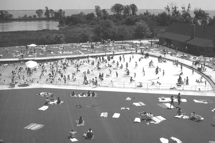
By late 1945, the HCMA had acquired 2,600 of the eventual 4,481 acres of forested hills, broad meadows, tamarack swamps, bogs, sloughs, and spectacular rural views that roll around Kent Lake and along both sides of the winding Huron River in Oakland and Livingston counties. Engineers quickly formulated plans to expand the sixty-acre lake into a 1,200-acre lake by clearing the land, then damming the river. They designed twenty miles of shoreline and scenic islands. When Kent Lake was completed late in 1946, it became the second largest inland lake within the five-county region. Swimmers flock to its two beaches, Martindale and Maple.
The park opened in 1948, offering picnicking, hiking, biking, horseback riding, play fields, nature study areas, and sledding hills. Depending on the season, the lake offered guests the chance to swim, boat, fish, ice fish, and ice skate. Two remodeled farmhouses provided camp facilities for groups and organizations. That first year, more than three thousand children slept within their walls, and three hundred secluded acres were set aside for organizations participating in camp programs. During the first summer, five thousand Boy Scouts gathered for “The Gold Rush of ‘48” area-wide camp-out. During the first two years, the camp site was used every weekend except for Easter and Christmas.
In its eighth year, Kensington offered rides on the Island Queen, a sixty-passenger paddle wheel excursion boat. Two years later, the Authority’s first nature center opened here. By its tenth anniversary, Kensington had welcomed its ten millionth visitor.
School groups and families have flocked to the Kensington Farm Learning Center ever since it opened in August 1976, as the Children’s Farm and Village. Here, on one hundred acres bordering the Huron River, they can pet and feed farm animals, tour the reconstructed barn, climb aboard a hay wagon or sleigh for a leisurely tour, and see, smell, and feel what farm life is all about. In the early years, a narrow-gauge railroad offered rides around the farm. The year after the farm center opened, the Authority’s 1977 biennial report explained, “City children especially are discovering the joys of country life in the new Children’s Farm and Village.” Originally operated by a private concessionaire, the farm was turned over to the Metroparks in 1980. At that time the Authority decided to abandon the railroad and the concessionaire’s plans for ten additional rides; the area was renamed the Farm Learning Center and its focus became educational.
Nowadays, Kensington’s nature center and seven trails also offer year-round adventures in learning. Labels along the trails point out the heron rookery and other birding highlights. The building features exhibits about the region’s natural history.
The forty-six-passenger Island Queen II offers tours of Kent Lake in the summer. Kensington’s eighteen-hole golf course is rated one of the top ten publicly owned courses in Michigan. Swimmers, canoeists, kayakers, and paddle boaters enjoy Kent Lake in the summer. A new water play area has been designed for children.
In the winter months, the park becomes a winter wonderland, as visitors climb up and hurtle down toboggan runs and sledding hills or soundlessly cross-country ski along groomed and marked trails. Skaters play hockey or glide around the two ice skating ponds. To ward off the chill, winter enthusiasts can gather around indoor fireplaces located in several buildings, or stop in at the Cross Country Ski Touring Center which in the summer months functions as a golf course starter building.
Kensington’s planners had originally estimated that the park would need to accommodate fifty thousand people on peak summer holidays, with two-thirds that number of people on weekends throughout the rest of the year. Six decades later, Kensington Metropark hosts 2.3 million visitors each year, making it the most popular year-round park in Michigan.
Opening dates:
- 1946 – Kent Lake increased from 60 acres to 1,200 acres.
- 1956 – Island Queen (a sixty passenger paddle wheel put into operation)
- 1961 – 6,345-yard, Par 71 Golf Course
- 1976 – Kensington Farm Center (formerly known as Childrens’ Farm and Village)
- 1996 – Mobile Learning Center
- 2000 – Wildwing Lake Board Walk
- 2007 – Splash ‘N’ Blast
- 2007 – Farm House Grille
Lower Huron Metropark
Opened to the public 1947 as Lower Huron Metropolitan Park.
Officially dedicated in 1953.
At the time of its founding, the HCMA decided to locate large recreational parks at strategic points along the river valleys, where different parks could provide different types of recreational opportunities. In 1946, the four-hundred-acre Kiskadden Farm went on the market. Located in the river valley halfway between French Landing and New Boston, it sat twenty-five miles away from Detroit and spanned both sides of the Huron River, an ideal setting for a large park in Wayne County.
This stretch of the Huron River meanders picturesquely through the old farmlands. Ravines and the tiny scenic streams emptying into the river are among the attractions for environmentalists, as are the rare and fascinating assortments of trees and shrubs that thrive here far from their core habitat; among them are the paw-paw and Kentucky coffee trees. Visitors flock to the park in the spring to see acres of redbud trees in bloom.
With plans to purchase more land in the area, the Authority opened the farmlands to the public almost as soon as the property was acquired, responding to the urgent post-war demand for recreation. By the spring of 1948, picnic sites and parking lots were available in Lower Huron. A local Boy Scout troop reconstructed an old cable suspension bridge across the Huron River, which gave visitors access to both riverbanks. Skating and fishing were encouraged along the river.
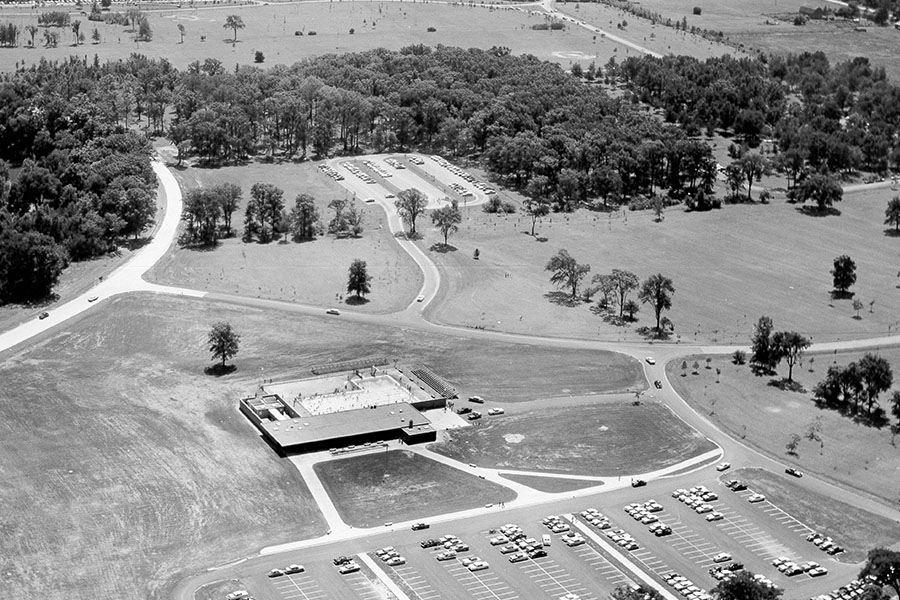
The Authority realized that this site was “possibly the last location for a major park in the lower Huron River area.” Within one year, 1,100 acres had been acquired and builders began constructing roads, sewers, and water systems on the former farmlands. By 1953, the original 425-acre park was preparing for its grand opening and first full season; park officials expected to double the number of the previous year’s visitors (425,000) as the public discovered the brand new picnic grounds, play areas, group camping, and nature trail.
Over time, the park has grown to encompass 1,258 acres of wooded hillsides, ravines, small springs, and streams. The HCMA’s first swimming pool opened here in 1958; later, the Metroparks’ first water slide joined the complex. A camp site for youth groups was carved out of the property; fifteen miles of bike-hike trails were designed to connect Lower Huron, Oakwoods, and Willow Metroparks; two nature trails were laid and labeled; a children’s play area was constructed; ball fields, tennis and basketball courts took over former agricultural fields.
Anglers can still find isolated shore-fishing sites where they can drop a line, bikers and hikers enjoy touring the park, and golfers tee off on the eighteen-hole, par-three golf course, which covers fifteen acres. In the winter, ice skaters glide across the park’s three natural ponds.
The park’s fifty-year-old swimming pool has been relegated to the past, replaced by an $8 million Family Aquatic Center.
Opening dates:
- 1961 – Par 3 Golf Course
- 1999 – Willow Connector Trail
- 2008 – Turtle Cove Family Aquatic Center
Lake St. Clair Metropark
(Formerly known as Metro Beach Metropark)
Opened on August 19, 1950. Dedicated 1951.
At its first meeting, in 1942, the Huron-Clinton Metropolitan Authority’s Board of Commissioners pinpointed the need for swim facilities, noting, “even though Detroit and its environs are located on the shores of the greatest fresh waterway in the world, satisfactory public bathing facilities have not been provided.” Metro Beach was designed as a premier swimming facility; in time it would encompass seven hundred seventy acres and stretch for more than a mile along Lake St. Clair.
Plans for Metro Beach were authorized as soon as World War II ended. The HCMA authorized surveys of the Detroit River and Lake St. Clair, and eventually spent $150,000 on the purchase of the first five hundred fifty acres at Huron Point on Lake St. Clair.
The site offered 7,500 feet of lake frontage, but a massive dredging project was required to transform swampland into the beach that would outline the park, which lies five miles south of Mt. Clemens and twenty-two miles northeast of downtown Detroit. Shortly after the war ended, the HCMA contracted for the removal of 2,200,000 cubic yards of sand from the lake for fill and beach-building, at a cost of $459,500. The following year, construction crews began work on a four-lane divided parkway and the facilities that were considered “ultra modern” at the time. Noted landscape architect Hugh Lamley designed the park, modeling it after Jones Beach in New York.
By the late 1940s, members of the public had the opportunity to study a model of the proposed two-million-dollar project and what was planned for different phases in the future: a beach six thousand feet long, with an average width of three hundred feet; a beach walk thirty feet wide; deck games; an eighteen-hole putt-putt golf course; a twenty-five-acre picnic area on a point surrounded by water on three sides; parking for five thousand automobiles; a boat dock and marine facilities, roller skating rink, a large swimming and diving pool complete with bleachers for exhibitions and competitions; a central administration building; and a bathhouse with lockers that would accommodate seven thousand visitors a day, plus food concessions and first aid stations.
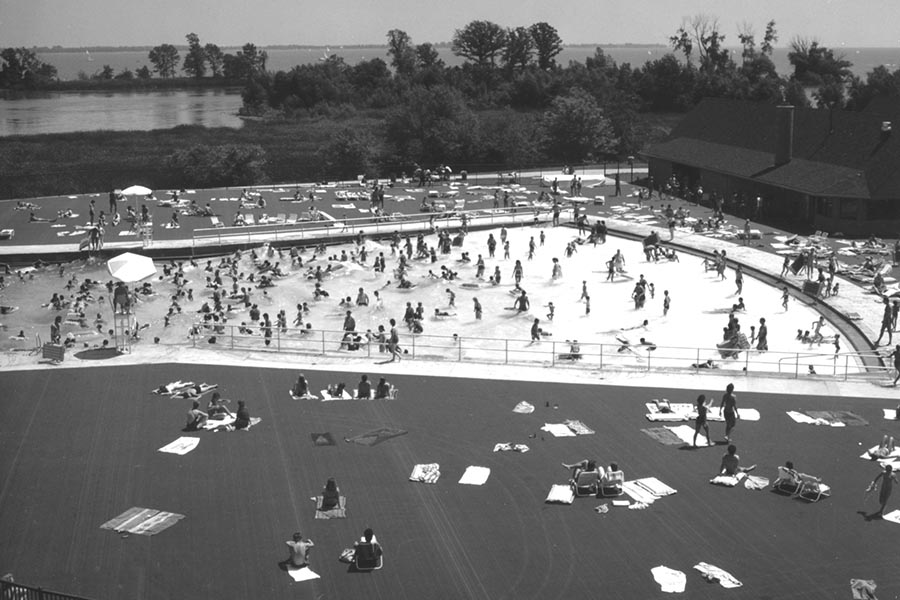
“A half-century ago, parks offering swimming had to offer many amenities we no longer need to provide,” explained Jim Pompo, who once served as superintendent of Metro Beach. “People came fully—and often formally—dressed. They expected to be able to rent bathing suits, dress in fully-equipped changing rooms, and store their clothes in lockers. Because of this, at the time Metro Beach opened, we needed a huge changing-room complex. Six thousand lockers were built to accommodate visitors eager to change and head to the beach.” When times and social customs changed, the massive changing-room facility was torn down.
On June 23, 1951, shortly after the finishing touches were made to the parkway entrance, Metro Beach officially opened with speeches, a day-long program, sports events on land and water, fireworks, and dancing under the stars. That summer, 100,000 visitors used the bathhouse facilities, which included a room equipped with baby bottles, food warmers, and “other furnishings for the convenience of mothers with infants.” The food bar served sandwiches, candy bars, soft drinks, and snacks to as many as ten thousand hungry visitors a day. Two inland boat basins invited all but the largest sail and power boats to stop for a visit. Months later, during the first winter of this Metropark, more than four thousand ice fishermen could be seen during frigid Sundays, and more than two thousand ice skaters would glide across the lake shore on a winter weekend day.
Because of its enormous popularity, Metro Beach expanded its facilities later in the 1950s, adding a marina, boardwalk, boat launch, Par-3 golf course, tot lot, outdoor roller skating rink, and dance area. In 1964, an Olympic-sized swimming pool opened to the public. In 1977, a thirty-six-hole putt-putt golf course was added. In 1985, a generous donor, Harry Fuller, bequeathed $50,000 and three dozen wildlife game mounts to the Authority, to be used as a nucleus for a nature center at Metro Beach. In 2001, the “Squirt Zone” water spray park opened.
A trackless train still brings visitors from the parking lots to the picnic areas on Huron Point, which offers scenic views of Lake St. Clair. People in-line skate, walk, or bicycle along the one-mile-long paved hike-bike trail along Huron Point. Swimmers can choose between Lake St. Clair and an Olympic-size pool. Boaters can use the boat-launch ramp on Black Creek to enter the Black Creek, which leads out to Lake St. Clair, and then on their return trip, they can pull their boats into a slip in one of the three marinas. Parents bring their children to enjoy the playground, while other visitors stroll along the 1,700-foot boardwalk, get in shape on the walking fitness course, play a round of golf, or visit the nature center. On the weekends, music lovers enter the park for evening concerts and dances. In the winter, ice fishing, ice skating, and cross-country skiing keep the park busy.
Opening dates:
- 1959 – South Marina
- 1962 – Tot Lot and Play Area
- 1964 – Olympic-sized swimming pool
- 1977 – 18-hole, Par-3 Golf Course
- 1989 – Nature Center
- 1993 – Shipwreck Lagoon Adventure Golf Course
- 1996 – Thomas S. Welsh Activity Center
- 2001 –“Squirt Zone” a zero-depth water spray park
- 2003 – Huron Point Shoreline Trail
Marshbank Metropark
Opened 1950. Transferred to West Bloomfield Township on October 8, 1987.
A civic-minded philanthropist who believed in the HCMA’s mission and served on its board, Howard B. Bloomer donated one hundred fifteen acres to the Authority as soon as the war ended in 1945. Located on Commerce Road southwest of Pontiac, this land had been his personal estate. It included two thousand feet of frontage on the western end of Cass Lake and eight hundred feet of frontage on Orchard Lake.
When the Authority acquired the land, maintenance crews immediately began a tree-planting program to provide shade trees for picnic areas. Two years later, bulldozers prepared the property for entry roads, parking lots, and playing fields. Marshbank was designed as a picnic site, with tables and shelters and boating access to the water.
Recognizing that the small, locally used park didn’t fit its mission, the Authority donated Marshbank to West Bloomfield Township in 1987, for one dollar and deed restrictions, ensuring that the park would remain a public facility throughout the ages.
Dexter-Huron Metropark
Opened 1952.
The Washtenaw County Road Commission transferred ownership of four tracts of land in Washtenaw County along the Huron River to the HCMA in the early 1950s. These two hundred twenty acres, which were the first acquisition on the Huron River between Belleville and Kensington Metropolitan Park, were divided into three Metroparks: Dexter-Huron, Delhi, and Hudson Mills. All three were originally intended for “passive recreation,” as places that would encourage an appreciation for nature, environmental restoration, and land preservation along the area’s ancient highway. In fact, Dexter-Huron already existed as an informal picnic area.
The one hundred twenty-three acres that created Dexter-Huron Metropark were redeveloped to offer picnic grounds, a fishermen’s Mecca, and launch sites for canoes. This park offers a scenic picnic spot on the river, shelters, playground equipment, and a ball diamond.
Delhi Metropark
Opened 1957.
“Dexter-Huron, Delhi, and Marshbank certainly didn’t fit into the original planning and development scheme as envisioned by the founding fathers, and later the HCMA Board,” Deputy Director Dave Moilanen explained. “Although all three were very small, ranging in size from fifty to one hundred twenty-five acres, the Board decided that politically it would be best to accept these parks.”
The Authority’s original plan had called for a string of roadside parks ranging along the Huron River, linking Delhi with Scio and Foster, two other sites where pioneer settlements once flourished, but the fifty-acre Delhi was the only one of the three to become a park. Because Delhi and Dexter-Huron are located along the Huron River near Hudson Mills, the Authority realized that the same staff could efficiently administer all three Metroparks in Washtenaw County as a unit.
Delhi Metropark was once the site of an early and thriving river settlement; sharp-sighted visitors can still see the foundations of old mills once powered by the Huron River. In the mid-nineteenth century, the hamlet of Delhi also boasted a livery stable, store, homes, outlying farms, and several other businesses.
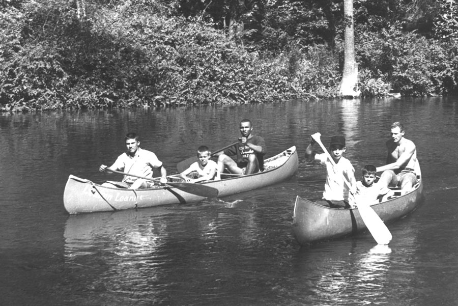
Continuing the development of recreational space along the Huron River, this mini-Metropark opened to visitors interested in picnicking, photographing, canoeing, kayaking, or just relaxing in a lovely and fairly remote natural setting. The Delhi Rapids rush past the banks of the river at this spot and trees shelter riverbank picnics and a large playground. For decades, a canoe livery has taken canoe enthusiasts from this spot upstream to Hudson Mills, where they can start a leisurely paddle along a beautiful stretch of the Huron River.
Opening dates:
- 2000 – Helen’s Adventure Park Playground
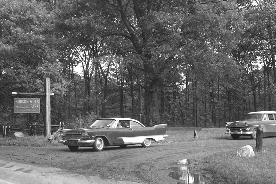
Hudson Mills Metropark
Opened 1957.
In the early nineteenth century, a small community flourished on the grounds of what would a century later become Hudson Mills Metropark. A grist mill, cider mill, plaster mill, saw mill, and small village known as Hudson Mills stood at the junction of the Huron River and North Territorial Road, just beyond the village of Dexter. Although the mills, shops, post office, barns, and several houses disappeared long ago, the name remained and was conferred on this park, the largest Metropark in Washtenaw County.
The land had originally been considered for the site of a metropolitan forest rather than a park, thanks to its magnificent stand of trees. However, the public asked for active rather than passive recreation, and the plans were changed. The 1,549-acre park opened with “activities suited to a relaxed pace.”
Along with the two other Metroparks in the county, Hudson Mills offers a popular stretch of the Huron River for canoeing. The park’s Acorn Nature Trail meanders for two miles, guiding hikers along shady areas and woodlands adjacent to the Huron River. Labels point out interesting plant life.
A three-and-a-half mile hike-bike trail now winds along the Huron River, through woods and open fields. Picnic grounds offer four shelters for group use. An activity center/administration building rents bicycles and skis, depending on the season, and provides food service during the summer months. Several years after the park opened, tennis courts, soccer fields, a play area, and four miles of groomed cross-country ski trails were added. The eighteen-hole, par-seventy-one golf course is open year-round, based on course conditions, and disc golf is especially popular in this park. Players have two twenty-four-hole courses where they can play. Organized youth camping is available; so are accommodations for canoeists and kayakers.
People come from miles around to Hudson Mills to view the Fourth of July fireworks, make maple syrup, view antique tractors, watch soccer tournaments and track-and-field meets, as well as to participate in other special events scheduled throughout the year.
Opening dates:
- 1991 – 18-hole, Par 71 Golf Course
Stony Creek Metropark
Opened on July 6, 1964.
Stony Creek vies with Kensington for the title of the largest of the Metroparks; they are within three acres of being the same size. Its history as a Metropark dates back to 1957, when the Authority began acquiring land in Oakland and Macomb counties for a new “full-sized” metropolitan park (at that time envisioned as 2,800 acres) patterned after Kensington. Stony Creek was launched by combining one hundred twenty-four parcels of purchased lands plus one hundred seventy-nine acres donated to the Authority and an additional four hundred fifty acres that were held in a life estate for several years. Stony Creek now offers 4,461 acres of scenic views, picnicking, swimming, fishing, boating, biking, hiking, golfing, ice fishing, ice skating, sledding, cross-country skiing, and tobogganing.
As was the case at Kensington, a lake expansion project was planned from the beginning. Engineers and landscape architects carefully analyzed the property, recognizing that a slight change in the crest elevation of the proposed dam would make dramatic changes in the size and shape of the new six-hundred-acre lake. Eventually, they decided to build two dams, creating two lakes where swimmers and boaters could enjoy the wide open spaces while anglers catch walleye, pike, perch, small mouth bass, bluegill, and crappie.
Before the land was flooded for the lake, the Authority salvaged 100,000 cubic yards of topsoil, which was stored and used for future landscape projects. Baypoint Beach, with a shoreline eight hundred feet long, opened just before Eastwood Beach. Visitors can borrow fishing poles or rent paddleboats, kayaks, and rowboats to enjoy the lake’s waters and views.
Thousands of years ago, glaciers formed Stony Creek, Reflection Pond, and the surrounding rolling terrain, which is now covered with dense woods, broad fields, and small stretches of wetlands. These provide the backdrop for six miles of nature trails that course through the area surrounding the nature center. An additional thirteen miles of trails intended for mountain bikers, hikers, and cross-country skiers are found in the southwest corner of the park; this is the only mountain bike trail system within the Metroparks. Another bike trail enters the park and loops around Stony Creek Lake for more than eight miles. Sledders, snowboarders, and tobogganers can choose between seven winter sports hills.
In the early 1960s, the commissioners decided to convert a large home on the property into a nature center. “That was supposed to be a short-term solution,” Moilanen pointed out, but ground wasn’t broken for its replacement until after the turn of the century. “The old home served us well for many, many years.”
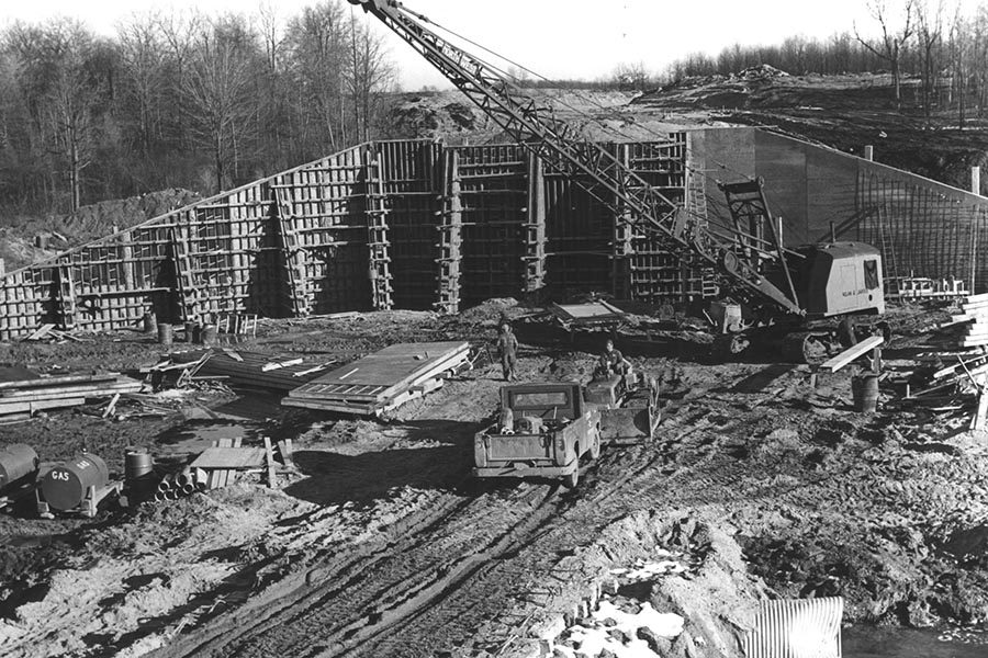
The Macomb County Road Commission selected nineteen remote acres of this Metropark for a mitigation project. The land was transformed into a wetland that has become a habitat for birds, turtles, frogs, and native wetland plants. When it was completed in 2003, the $1.3 million project became the largest artificially made wetland within the Metropark system. Adjacent to the mitigation site, the five-mile-long Inwood Hiking Trail System was developed on seven hundred acres; it includes a long plank walkway spanning dramatic natural scenery.
Opening dates:
- 1970 – Eastwood Beach
- 2006 – 6,928 yard, Par 72 Golf Course (concessionaire’s 36 year lease expired)
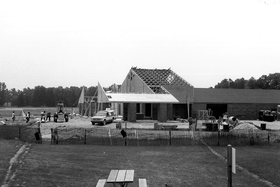
- 2007 – New Nature Center Building
Willow Metropark
Opened June, 1970.
Stretching across 1,531 acres ranging along the Huron River, south of Lower Huron Metropark and northwest of Oakwoods Metropark, Willow became the ninth Metropark in the system. Like Lower Huron, this park opened almost immediately after the first land acquisitions in order to meet public demands for recreation; initially, only play equipment and a few picnic areas were available.
A $100 million bond program approved by Michigan voters in 1968 granted funds for an Olympic-sized swimming pool at Willow and a game area that officially opened on June 8, 1976, with courts for tennis, shuffleboard, and basketball, and a children’s play area near the pool, bathhouse, and food bar. More than twenty-five years later, the tennis courts were converted into a skate park offering in-line skaters, skateboarders, and bicyclists a half-pipe ramp and other challenges. Dancers enjoy weekend programs and special events at the open-air dance pavilion, and when they get hungry, food service is available.
Washago Pond is a particularly scenic spot for picnics and a favorite site for fishing. Visitors can borrow fishing poles or rent rowboats, paddleboats, and single-speed bicycles here.
The park stays active year-round. An eighteen-hole regulation golf course and driving range are located in the southern part of the park. Disc golfers play year-round at the park’s eighteen-hole course. A four-and-a-half-mile hike-bike trail connects all the major facilities within the park; the trail’s extension brings bicyclists and hikers to Oakwoods and Lower Huron Metroparks. In the snowy winter months, sledders and cross-country skiers make use of the hills and trails, and whenever the ice is thick enough, skaters glide across the pond.
Opening dates:
- 1976 – 6,378 yard, Par 71 Golf Course
- 1976 – Willow Pool
- 2003 – Skate Park
[/accordion-item][accordion-item title=”Oakwoods Metropark” id=9 state=closed]
Oakwoods Metropark
Opened on May 8, 1975.
Oakwoods Metropark covers 1,756 acres northwest of Flat Rock in southern Wayne County. This area is rich in Native American history; in the early 1800s, it formed part of the Wyandot Indian Reservation.
A 1968 bond program provided funding for the Oakwoods Nature Center, which opened to the public in 1975. The 6,800-square-foot facility offers hands-on exhibits and seasonal displays, an indoor turtle pond, and auditorium. Outdoors, the nature study area covers four hundred acres and features an ancient sandbar, backwater trails for canoeists, five nature trails, a three-acre pond, and a butterfly garden.
Interpreters lead visitors on nature tours and voyageur canoe adventures past the nesting grounds and feeding territories of egrets, herons, turtles, and the other wildlife that make their homes on or near the backwaters of the Huron River. Four nature trails guide visitors through the land’s important natural features: the Split Log Trail (a woodland experience), the Big Tree Trail (featuring trees, wildflowers, and birds), the Long Bark Trail (where a post-glacial beach line can be identified and the various stages of lake development are pointed out), and Sky-Come-Down Trail (which wanders over long-abandoned farm fields and past a three-acre pond created for aquatic life studies).
Oakwoods is the flattest of the Metroparks, which makes its trails particularly appealing to beginning joggers, hikers, and bicyclists; the land features tall trees, wonderful woodland scenery, and the Huron River’s backwaters. Equestrians enjoy the five miles of horse trails—and, speaking of trails, Oakwoods is one end of the hike-bike trail that stretches to Lower Huron Metropark.
Opening dates:
- 1975 – Nature Center
Lake Erie Metropark
Opened on June 28, 1980.
Located in Wayne County’s Brownstown Township, the land that now comprises Lake Erie Metropark was seen as an ideal location for a large metropolitan park because of its access to Detroit, the Detroit River, and one of the Great Lakes. This Metropark preserves sensitive natural areas, including hundreds of acres of wetlands and three miles of Lake Erie shoreline, while also providing a wide variety of recreational activities. The 1,607-acre complex is one of the best bird-watching sites in the state. The area teems with waterfowl and wildlife; the park lies beneath the migration route for butterflies, raptors (birds of prey), and other winged visitors.
Nearly three-fourths of the park was purchased outright in 1975; five years later, visitors were first welcomed for shoreline picnicking and fishing. Soon afterwards, a marina at the southern end of the site was acquired from a private owner; this provided boating visitors with access to and from Lake Erie and the Detroit River. A $2.5 million special activities area was constructed in 1982, but the park’s visitation skyrocketed in 1985, when the “Great Wave” pool opened. The 453,000-gallon wave action swimming pool generates three-foot waves and can accommodate 1,400 visitors at a time. Adjacent to the pool is a bathhouse, games area, playground, and food bar.
Lake Erie Metropark’s nature interpretive area helps preserve a very valuable and endangered portion of the Great Lakes Marsh. The nature study area covers two hundred acres of marshes, hawthorn thickets, old canals, and a reconstructed boathouse, all of which offer views of wildlife and the coastal marsh habitat. Visitors flock to see raptors migrating in the autumn, while thousands of waterfowl can also be observed in the offshore waters and marshes. Tundra swans swim here in winter. Muskrats and rare fox snakes make their homes here, and huge beds of American lotus plants bloom late in the summer. The Trapper Run Trail explores the marsh and shoreline, and the Cherry Island Marsh Trail journeys through coastal marshes, past Lake Erie and the Detroit River.
Construction began on the $1 million William E. Kreger Marshlands Museum and Nature Center in 1992; three years later, it opened with the help of a $750,000 grant provided by the “Protecting Michigan’s Future” Bond Program. The museum houses exhibits and displays relating to the area’s rich history of duck hunting, Native American culture, and marshland life. A 1,300-gallon aquarium houses regional fish species and the “Muskrat Club” offer small children interactive environmental activities.
For those who want to enjoy a leisurely afternoon—or week—of boating, duck hunting, or viewing the Lake Erie shoreline and its waterfowl from the lake or river, a $522,000 boat launch facility opened in the early 1990s. On the south end of the park, golfers enjoy the eighteen-hole, par-seventy-two course, which is surrounded by natural wetlands and encompasses twenty acres of ponds.
Opening dates:
- 1993 – 6,472 yard, Par 72 Golf Course
- 1985 – Great Wave Pool
- 1995 – Marshlands Museum and Nature Center
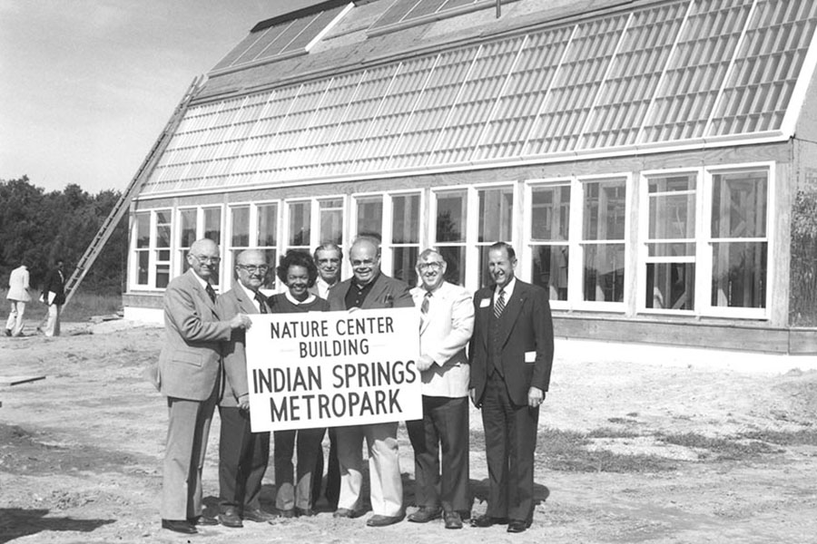
Indian Springs Metropark
Opened June, 1982.
This Metropark spreads across 2,217 acres northwest of Pontiac in Oakland County, at the headwaters of the Huron River. Its “Andersonville Swamp” (now known as Huron Swamp) was the largest undeveloped natural area remaining in southeastern Michigan when the Authority began acquiring the land in 1974. Within a year, 1,037 acres had been purchased. The Authority’s goal for this property was to preserve the wetlands, grasslands, Timberland Lake, and prairies in their original condition, in order to focus on interpretive opportunities and public education about the natural environment. Its facilities do, however, include an eighteen-hole golf course, hike-bike trails, cross-country ski trails, a nature center, Spray ‘n’ Play, and a state-of-art Environmental Discovery Center that provides twenty-first-century adventures in the natural sciences.
Indian Springs calls its official opening the day in 1982 when the nature center first opened its doors. The 2,400-square-foot center was a leader in environmental education at the time; it was solar heated, to demonstrate how the sun can be utilized to provide heating, cooling, lighting, and food production throughout four seasons of the year without polluting or altering the natural environment. Within three years, a 3,000-square-foot addition offered expanded exhibit space, a classroom, and multi-purpose room.
The Authority developed plans for a magnificent Family Aquatic Center at Indian Springs in the mid-1990s, but local communities pointed to an existing water park nearby and the Authority changed its plans. Engineers and naturalists designed and developed an Environmental Discovery Center unlike any other facility in the state; it opened in 2005. Adjacent to a 1.7-acre constructed kettle lake with viewing areas below its surface, on the surface, and above the surface, the center houses a fully equipped biology laboratory.
“This interpretive center is very different from anything else we’ve ever done,” Moilanen explained. “It allows us to move into the twenty-first century with our interpretive program. We tie in with science benchmarks at the schools. Our labs are interactive, with hands-on activities and state-of-the-art technology.”
Indian Springs’ eighteen-hole, par-seventy-one golf course includes a driving range. The Spray ‘n’ Play features a water play area, a maze, a rock-climbing wall, and a special play place for tots. The park’s nature trails and hike-bike paths lead visitors through swamps, across meadows and fields, into woodlands, and past rejuvenating prairie lands. Interpretive labels provide local history and information about native plants and wildlife. In winter, skiers take over the ten miles of trails.
Opening dates:
- 1988 – 6,688-yard, Par-71 Golf Course
- 2005 – Environmental Discovery Center
- 2006 – Spray ‘N’ Play
Huron Meadows Metropark
Opened June, 1984.
Covering 1,566 acres south of Brighton in Green Oak Township, Huron Meadows in 1984 became the first Metropark to be solely located in Livingston County. Dense woods and rolling meadows follow the flow of the Huron River. Maltby Lake is a magnet for visitors who come to picnic, fish, and enjoy a leisurely hour—or day—boating; a fishing pier attracts anglers of all ages, and paddleboats and rowboats can be rented for use on the lake. Metroparks founding father Henry Curtis, who decried the use of motor boats on rivers and lakes, would be pleased to know that no gasoline engines are allowed on this lake. Veteran canoeists and kayakers often start long treks along the Huron River from this park.
In 1984, the eighteen-hole, par-seventy-two golf course opened with a 5,700-square-foot- combination golf/activities center building, which offers food service and a meeting room. In the late 1980s, the building was named for former Commissioner Clifton W. Heller, who served Livingston County on the Authority for many years. In winter months, the golf center becomes the Cross Country Ski Touring Center, offering ski equipment rentals, food, and maps for the Metropark’s seven miles of groomed trails. Skiers weave through the park while ice fishermen drop their lines in Maltby Lake.
Opening dates:
- 1984 – 18-hole, Par 72 Golf Course
- 1984 – Golf/Activities Center Building
Wolcott Mill Metropark
Opened July, 1989.
“When I was director, my biggest challenge was acquiring Wolcott Mill,” James Pompo recalled. “[Former Director] Dave Laidlaw had once been thrown out of the township office when he tried to discuss the acquisition. Then [Commissioner] Tom Welsh tried. We had a debate on the radio and one of the township officials told us, ‘If either that Laidlaw or Welsh comes into the township again, they’ll duplicate John the Baptist—their heads will be served on a platter.’ Later on, I met with township supervisor Don Martens five times before the park issue came to a vote—and it passed with all but one in favor. By that time, township authorities were afraid that McDonald’s and other fast-food businesses would be buying up the land.”
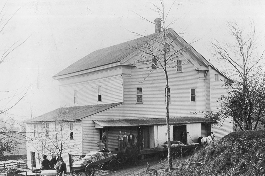
A grist mill built in 1847 loaned its name and fame when it was selected as the historical interpretive center for this Metropark in Macomb County. The mill preserves an important and bygone era in the state’s history. At the time the grist mill was built, Michigan had thousands of small mill operations and most local farms grew winter white and red wheat; nowadays, only five gristmills still operate in the state and most winter white wheat is imported from Ontario. Wolcott Mill remained in continuous operation by several generations of one family until 1967.
When the Authority purchased the 225-acre property in 1979, the grist mill came complete with all its grain-grinding machinery, power source, mill pond, dam site, delivery truck, and adjacent buildings. It took ten years for the mill and its property to be restored and opened to the public; now, the mill is open to visitors seven days a week May through October, and Wednesday through Sunday, November through April, with interpreters available to give programs or show visitors the workings of the mill.
Over time, the park has grown to encompass in excess of 2,800 acres along the North Branch of the Clinton River. This park consists of four sections: the mill, Farm Learning Center, golf course, and Camp Rotary. The Authority plans to connect these four sections into one large Metropark when all necessary land acquisitions are completed. The group camp facility and its lodges, activity center, observatory, and tent camp sites were acquired from the local Rotary Club in 1996. The park’s Equestrian Center offers ten miles of trails, while model airplane enthusiasts take to the skies, making use of the Metropark’s model airplane airport on the grounds, operated in partnership with the Romeo Model Airplane Club.
Horses, dairy cows, beef cattle, goats, and sheep graze at the nearby 250-acre Farm Learning Center on Wolcott Road, which opened to the public in the fall of 1997. Chickens, ducks, and turkeys lay eggs in the farmyard and hen houses and 160 acres of crops are planted each year. A modern working farm with twenty-two dairy cows, the Farm Learning Center sells milk to a dairy processor and demonstrates farming techniques, including an automated milking system and state-of-the-art agricultural waste-handling system. The farm’s original dairy, sheep, and horse barns were salvaged and renovated; they are in daily use. A new farmhouse was built after the park opened, to serve as an exhibit area, classroom, and staff office.
Opening Dates:
- 1997 – 6,266-yard, Par 72 track Golf Course (formerly known as Northbrook Golf Course)
- 1997 – Camp Rotary
- 1997 – Farm Learning Center
- 2000 – Equestrian Trail
 YOUR ACCOUNT